Thumbnail
view
The thumbnail shows the view today.
The thumbnail shows the view today.
Details
about the two photos used in the 'Then and now'
Click the thumbnail to view.
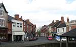
Image Reference No. : DP-TAN-MELB-76
Details : This view shows the High Street in Melbourne town.
Things to look for : There are some subtle changes to see here as well as the more obvious ones such as the co-op sign.
Photo A taken : 1920 (postcard)
Photo B taken : 29th April 2005
Time elapsed : 85 years
Exact Map Location : click HERE.
Click the thumbnail to view.
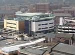
Image Reference No. : DP-TAN-DCTV4-77
Details : This view shows the view from the top of Derby Cathedral looking towards the old west end area of Derby and clearly shows the construction of the new college building.
Things to look for : The Joseph Wright Sixth Form Centre appears from nowhere. Very fast construction!. The Millhouse (new luxury apartments) on Bridge street also appear.
For more details on the Joseph Wright centre click HERE.
Photo A taken : 12th April 2004
Photo B taken : 28th March 2005
Time elapsed : 11 months
Exact Map Location : click HERE.
To watch a time-lapse video of the construction of this building click HERE.
Click the thumbnail to view.
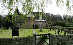
Image Reference No. : DP-TAN-DALE-78
Details : This view shows the Church of All Saints in the quiet village of Dale Abbey.
Things to look for : When I created this one I thought I had got the calculations wrong when I saw the wall move but it would appear that the stone wall has been extended at some point, perhaps to increase the burial ground area available to the church.
If you know when and why this happened please get in touch.
Photo A taken : 1920's (postcard)
Photo B taken : 17th April 2005
Time elapsed : 85 years
Exact Map Location : click HERE.
I would like to thank Garth Newton for providing photo A.
Click the thumbnail to view.
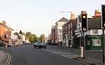
Image Reference No. : DP-TAN-ASHUTTOX-79
Details : This view shows the road junction where Ashbourne Road meets Uttoxeter Old.
In photo B - The shops on the right of the photo (nearest first) are Friargate Racing, The Tuck-in, Bookstall Forum (closed), Goodalls Butcher and Gorjuss (a Salon, which opened 28th April 2005).
Goodalls Butchers at 6 Ashbourne Road has been on this corner since the 1880's. The Congregational Church on the right was built in 1865 and it was originally called Victoria Mission Hall. The church was damaged by a fire in 1994 and was demolished in 2001 and apartments known as 1018 built on the land in 2002, see HERE.
I had to risk life and limb to take the now photo as this road is rather busy, unlike the original photo!
Photo A taken : 1910 (postcard)
Photo B taken : 11th May 2005
Time elapsed : 95 years
Exact Map Location : click HERE.
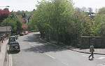
Click the thumbnail to view.
Image Reference No. : DP-TAN-ASHRAIL-80
Details : This view shows the former Railway station in the town of Ashbourne.
The road leading off centre is Station Street.
I would like to thank Spurrier-Smith Antiques of 39 Church Street, Ashbourne for allowing me access to take my now photo.
Photo A taken : 1920 (postcard)
Photo B taken : 13th May 2005
Time elapsed : 85 years
Exact Map Location : click HERE.