Thumbnail
view
The thumbnail shows the view today.
The thumbnail shows the view today.
Details
about the two photos used in the 'Then and now'
Click the thumbnail to view.
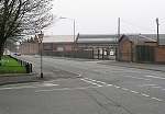
Image Reference No. : DP-TAN-COTT-71
Details : This view shows the junction of Cotton Lane with Osmaston Rd. The cake shop on this corner sold Birds Cakes until 1962 then was a bookmakers owned by George Siddal, then by his son until 1970 when it was demolished.The building on the right side of Osmaston road was Carriage & Wagon works canteen Today this is Bombardier.
In 1970's the streets of Graham street, Gilman street and Russel street were demolished. They have remained as parkland since then.
Directly Behind me is the Wayfarer Cafe at 324-326 Osmaston Road.
Things to look for : Demolition of the shop on the corner, there are some serious changes here with only one building on the right remaining. Notice the subtle things such as the colour of the wall where the orignal sign was fitted to the building on the right.
Photo A taken : 1968
Photo B taken : 3rd April 2005
Time elapsed : 37 years
Exact Map Location : click HERE.
I would like to thank Dave Upton for providing Photo A, See his other photos on my page here.

Click the thumbnail to view.
Image Reference No. : DP-TAN-MANH-72
Details : This view shows the former Manor hospital which was first developed as The Uttoxeter Road Workhouse, It was built in 1876-8 by local architects William Giles and Robert and Thomas Brookhouse who specialised in public and church buildings. The workhouse later became known as the Boundary House Institution, then after 1948 as Manor Hospital. The hospital closed in 1988 and was demolished in 1992
Things to look for : Demolition of a fine looking building which as you can see was replaced by a Beefeater and an Aldi supermarket !
Photo A taken : 1992 Feb
Photo B taken : 10th April 2005
Time elapsed : 13 years
Exact Map Location : click HERE.
I would like to thank Les Sims for providing Photo A, See his other photos on my page here.

Click the thumbnail to view.
Image Reference No. : DP-TAN-DRI-73
Details : This view shows the original frontage of the Derbyshire Royal Infirmary and the current one. Queen Victoria laid the foundation stone in 1891 on the site of the old infirmary of 1810. The concrete frontage was built in 1972, I think I prefer the original front.
Things to look for : The central part of the DRI is replaced by a horrible concrete one.
Photo A taken : 1905 (postcard)
Photo B taken : 18th March 2005
Time elapsed : 100 years
Exact Map Location : click HERE.
Click the thumbnail to view.
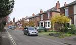
Image Reference No. : DP-TAN-DRI-74
Details : This view shows a street scene on Gordon Road in Borrowash looking towards Borrowash Methodist church (built 1899). Today this road is a one way road.
Things to look for : The two Monkey puzzle trees vanish. The front walls of the gardens are replaced with open areas for car parking.
Photo A taken : 1930's (postcard)
Photo B taken : 17th April 2005
Time elapsed : 75 years
Exact Map Location : click HERE.
I would like to thank Garth Newton for providing photo A.
If you currently live on Gordon Road then please get in touch.
Click the thumbnail to view.
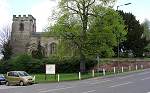
Image Reference No. : DP-TAN-ETW-75
Details : This view shows the church of St Helen. The Port Hospital Almshouses are located at the back of this church to the right of the photo.
Things to look for : Not a lot of changes but the trees have grown and the millenuim village sign has been erected.
Photo A taken : 1970's (postcard)
Photo B taken : 29th April 2005
Time elapsed : 35 years
Exact Map Location : click HERE.