Thumbnail
view
The thumbnail shows the view today.
The thumbnail shows the view today.
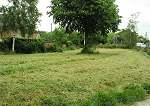
Details
about the two photos used in the 'Then and now'
Click the thumbnail to view.
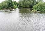
Image Reference No. : DP-TAN-LONGBRIDGE-101
Details : This view shows a structure which was known as "long bridge". It was a walkway for horses to pull canal boats across the river Derwent from the former Derby Canal across the river into the Northern part of the Canal system.
Photo A taken : 1950s
Photo B taken : 12th June 2005
Time elapsed : 45 years
Exact Map Location : click HERE.
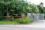
Click the thumbnail to view.
Image Reference No. : DP-TAN-BORROWLOCK-102
Details : This shows a view of the former Derby Canal at Borrowash. In photo A, the two swans are in a section of the Derby Canal just a few yards east of what was once Borrowash Top Lock, today this section of the canal is covered over and you would be forgiven for not even knowing that there used to be a canal through here. When the Derby Canal was closed, Station Road which runs across it was lowered down, the original bridge over the canal can be seen in Photo A.
The Derby Canal is currently being restored by the Derby Canal society, This section of the former Derby Canal WILL be transformed back into a canal in the not too distant future, please support the society in restoring the canal by joining here : www.derbycanal.org.uk
Photo A taken : 1950s
Photo B taken : 10th June 2005
Time elapsed : 55 years
Exact Map Location : click HERE.
Click the thumbnail to view.
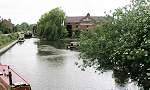
Image Reference No. : DP-TAN-SHARDLOW2-103
Details : This shows a view of Shardlow Basin where the Trent and Mersey canal runs close to the River Trent.
Photo A taken : 1970s
Photo B taken : 10th June 2005
Time elapsed : 35 years
Exact Map Location : click HERE.
Click the thumbnail to view.
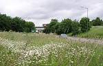
Image Reference No. : DP-TAN-LITTLEEAT-104
Details : This shows a view of the Little Eaton branch of the former Derby Canal.
In photo A you can see Little Eaton Top lock house. A few hundred yards behind this view would have run the viaduct of the Railway to Breadsall village.
Photo A taken : 1910 (Postcard)
Photo B taken : 17th June 2005
Time elapsed : 95 years
Exact Map Location : click HERE.
Click the thumbnail to view.
Image Reference No. : DP-TAN-LITTLEEAT2-105
Details : This shows a view of the Little Eaton branch of the former Derby Canal where it meets up with the Little Eaton Gangway. As you can see only the chimney stacks and part of the corner of the wharf building can be seen today, The Derby Canal and the gangway have long since gone from this scene.
In Photo A the Clock house served as a Wharf Agent's Office.
If you would like to learn more about the Little Eaton gangway then I recommend reading The Little Eaton Gangway & Derby Canal by David Ripley ISBN 0-85361-431-8
Photo A taken : 1908
Photo B taken : 17th June 2005
Time elapsed : 97 years
Exact Map Location : click HERE.