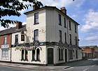
Image Reference No. : DP-230504SBSNOTTROAD-01
Exact map location : Click HERE
Date photo taken : 23rd May 2004
Other Information : This is The Tavern pub at 123 Nottingham Road. This pub was built in 1874 as the Station Hotel to serve the passengers who arrived at Nottingham Road Railway Station, The Midland Railway opened in 1856. The station no longer exists. The pub was renamed as the Tavern in June 1997. The road going off to the right is Clarke Street.
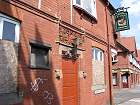
Image Reference No. : DP-230504SBSNOTTROAD-02
Exact map location : Click HERE
Date photo taken : 23rd May 2004
Other Information : This is the abandoned Liversage Arms pub at 63 Nottingham Road. It was built and owned by the trustees of the Liversage Charity in 1850. This pub closed in 2002.
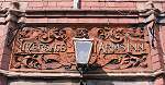
Photo
Description : The Liversage Arms terracotta
Image Reference No. : DP-230504SBSNOTTROAD-03
Exact map location : Click HERE
Date photo taken : 23rd May 2004
Other Information : Above the doorway of the Liversage Arms pub you will
find this decorative terracotta plaque. It was designed by Alexander MacPherson
and features the coat of arms of Robert Liversage.
This was the first station out of Derby, opened in 1856. A popular station because of its close proximity to the town centre and also the Derby Racecource. During race days punters would use this station as well as it being used to unload Horses.
This station closed on March 6th 1967.
