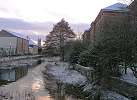
Image Reference No. : DP-270204SBSMARK-01
Exact map location : Click HERE
Date photo taken : 27th February 2004
Other Information : This is Markeaton Brook as viewed from the Footbridge, looking East towards Derby Cathedral. This footbridge links to the end of Searl Street (to the right of this photo)
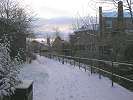
Image Reference No. : DP-270204SBSMARK-02
Exact map location : Click HERE
Date photo taken : 27th February 2004
Other Information : This is Markeaton Brook Walk near the Bridge Street Entrance. A rare snowy scene.
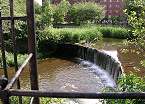
Image Reference No. : DP-160504SBSMARK-03
Exact map location : Click HERE
Date photo taken : 16th May 2004
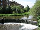
Image Reference No. : DP-030504SBSMARK-04
Exact map location : Click HERE
Date photo taken : 3rd May 2004
Other Information : This is Markeaton Brook Weir near Ford Street.
At the edge of Ford street, This culvert is the last time that Markeaton brook can be seen until it re-appears into the river Derwent by Station Approach. It travels underground to Bold lane, the strand, Victoria street and then emerges into the Derwent at Station Approach. It used to emerge into the Derwent at the River Gardens but in the 1970's it was diverted to Station Approach.
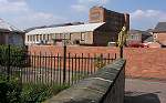
Image Reference No. : DP-160504SBSMARK-05
Exact map location : Click HERE
Date photo taken : 16th May 2004
