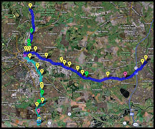
Derby Canal Route Map :
I have recreated my map April 2021 due to accidentally
deleting the previous one.
On my map I have traced the entire original route of the Derby
Canal. Using the Satellite mapping function in Google Maps you
can clearly see certain sections of the Derby Canal. I have also
used Google Streetview in many locations along the route to
identify Canal bridges and paths. Sometimes even though the
Canal has gone, the bridge over it remains in place. Some
markers have links to 360 degree views of the at location.
Some of the markers I have placed in my map have small
photographs in them, click on them to view a larger version.
These photographs were taken by Flickr photographers. If YOU
have any photographs of things along this route that I have not
included then please get in touch so I can add them.
IF you can help please join my Derby
Canal Flickr Group.
I have put a lot of time and effort into making sure my Derby
Canal route path and markers are correctly positioned but in
some areas I may be off slightly, please let me know if this is
the case. In those areas where there was no clear route using
the Satellite map I had to guess by using bridges either side
for reference combined with some old maps of the route.
I hope you find my Derby Canal Route map of interest, perhaps
you will learn something from it that you did not know before.
You can either view the whole Derby
Canal System map and then zoom in on the sections of the canal
you want to see or you can use one of the links I have
provided below that will take you straight to points of interest
along the route such as Locks and bridges.
Quick Links : Clicking one of these links will give you a zoomed
in centered view of that location.
Swarkestone
Junction Derby Canal and Trent and Mersey Canal.
Baltimore
Bridge orignal site of.
Fullen's
Lock remains of.
Shelton
Lock remains of.
Boulton
Lane Bridge site of.
Bracken's
Lane bridge site of.
Harvey
Road bridge site of.
London
Road bridge.
Bemrose
Arm site of.
Long
Bridge site of.
Pegg's
Bridge site of.
Ullicker's
Bridge.
Borrowash
Bottom Lock inc 360 views (restored).
Cockayne's
Bridge.
Sandiacre
Lock junction with Erewash Canal.
Click the thumbnail above to view my
entire Derby Canal System map.