Home
> Derbyshire Villages > Rowsley |
This page
features pictures and historical information about the following:
Rowsley, This is located in North Derbyshire.
If you would like
to see photos of other Areas of Derby, Derbyshire and the Midlands then
click on the main index button at the bottom of this page. |
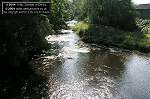
Photos of Rowsley, Derbyshire, England. 
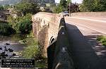
The small village or Rowsley is located on the A6 north of Darley Dale. The river Derwent and the river Wye merge at this village. 
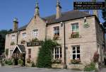
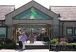
The Peacock Hotel has been a hotel since 1820, built originally as a private house for John Stevenson founder of the Lady Manners school in Bakewell. A carved Peacock stands over the porch and is actually part of the family crest of the Manners family, whose descendents live at nearby Haddon Hall. Caudwell's Mill On the banks of the river Wye lies Caudwell's Mill, A unique grade II listed historic roller flour mill. A mill has stood on the site for at least 400 years, the present mill was built in 1874 and is powered by water from the river Wye. Caudwell’s Mill is powered by the River Wye and is the only complete Victorian working roller flour mill in the United Kingdom. There are a number of craft shops as well as a well stocked gift shop, artist’s gallery and café. 
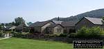
Peak Village factory outlet (shopping centre) is on Chatsworth road, which is an extensive factory outlet shopping centre. In the middle of the outlet is Rowsley Railway station. The station was constructed as part of the Manchester, Buxton, Matlock and Midland Junction Railway, which, despite its name, only managed to construct a line between Ambergate, Matlock and Rowsley and opened in 1849. The intention had been to continue the line northwards past Chatsworth, but when the Midland Railway eventually took the line forwards to Buxton in 1862, a route to the west via Bakewell and Monsalldale was adopted. This meant that a new station had to be built to serve Rowsley on a different site. The original station remained in use as a goods depot at the end of a dead end spur until 1968. The site was then used as a contractors yard before being redeveloped as you see it today. For a map of the local area click HERE For a aerial photo with overlayed map click HERE |
Photo
Description : The Grouse and Claret pub Image Reference No. : DP-040803ROWSLEY-01 Date photo taken : 4th August 2003 Other Information : This pub was formerly the Station Hotel, but due to the demise of the railway it was renamed. |
|
Photo
Description : Rowsley bridge Image Reference No. : DP-040803ROWSLEY-02 Date photo taken : 4th August 2003 Other Information : This is Rowsley bridge which carries the A6 over the river Derwent. It was widened in 1925/26 |
|
Photo
Description : The Peacock Hotel Image Reference No. : DP-040803ROWSLEY-03 Date photo taken : 4th August 2003 Other Information : This hotel was built in 1652. The inscription above the doorway reads "John Stevenson" with the N's backwards ! For more details on this hotel visit their website HERE. |
Photo
Description : The village well Image Reference No. : DP-040803ROWSLEY-04 Date photo taken : 4th August 2003 Other Information : This well (now dry) was built in 1841 and is located next to the Peacock Hotel. |
|
Photo
Description : The River Derwent Image Reference No. : DP-040803ROWSLEY-05 Date photo taken : 4th August 2003 Other Information : This is a view of the summer sun reflecting off the River Derwent as it flows downstream. This is the view from the middle of Rowsley bridge. |
|
Photo
Description : The Peak Village outlet Image Reference No. : DP-040803ROWSLEY-06 Date photo taken : 4th August 2003 Other Information : This is a large shopping outlet called Peak Village. For more info please visit their website HERE. |
|
Photo
Description : The Peak Village outlet - side view Image Reference No. : DP-040803ROWSLEY-07 Date photo taken : 4th August 2003 Other Information : This is a view of the Peak Village as seen from the Grouse and Claret pub area. |
Click
the button below to go to the main index of www.derbyphotos.co.uk |
© www.derbyphotos.co.uk