•
Photos of Hollington, Derbyshire, England.
The
tiny village of Hollington is set in a farming area close to which runs
the Shirley Brook to the west and Brailsford Brook to the east.
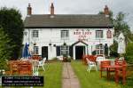
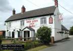
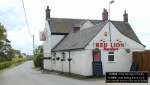
The Red Lion pub is located on Longford road.
In 1086, Hollington was recorded in the Domesday Book; the name was spelt
‘Holintune’ at the time. The name came from two old English
words, holeyn and tun, meaning The Farmstead where Holly grows. It was listed
under the lands of Henry de Ferrers.
At the time of
the Enclosure Act of 1817, Hollington was split between the parishes of
Longford and Brailsford. The act marked the end of the open field system
of farming, which had been in use in Hollington, up to the Act coming into
force.
The soil in the area is good quality Keuper Marl, well suited to grassland
farming and milk production and Hollington remains a predominantly farming
village. Up to about 50 years ago there were 17/18 farms in the village,
many of them quite small with only a few animals.
The economies of scale have led to much larger farm units operating in recent
years. As the old farmers retired, there land has been purchased and combined
with that of larger farms.
Before the 1950s when water was piped to Hollington, the absence of a good
water supply was a handicap to farming. Previously most farms and cottages
had to either pump water up from a well or obtain it from a rainwater storage
tank. In dry summers, the farmers were particularly inconvenienced, when
the ponds used to water stock dried up. They then had to drawer water from
very deep wells, to satisfy the thirst of their animals.
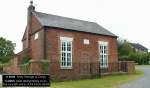
In the 1870s a National School was built by the villagers in Hoargate Lane,
complete with a bell tower and separate yards for boys and girls. A few
years later, it became a Church of England School. The school was used for
a number of activities and was the venue for Christmas Parties in the 1950s
and early 1960s. The school is no longer in existence.
Hollington does not have a church in the village, but the parish records
of Longford Church go back to 1538, in the reign of Henry VIII. Until near
the end of the 19th century, there were five other villages in the parish:
Longford and Thurvaston, Hollington, Rodsley, Hungry Bentley and Alkmonton.
The chapel built
in 1847 was very well attended for many years. It held anniversary celebrations
each year attended by all the children in the village, arranged annual trips
for the youngsters and held a popular harvest festival. The chapel held
its final service in 1992; three years later, it was sold and converted
into a house.
Lodge Farm is
a Grade II listed building, is the oldest surviving building in Hollington.
It is over 500 years old and contains elements of a 15th century timber
framed building.
The Millennium
Day Celebrations took place on the 15 July 2000, and followed the pattern
of the Queen’s Jubilee, 25 years previously, with additionally a village
photograph, barn dance and hog roast. A number of other events were held,
with the village fete proving to be the biggest fundraiser. Hollington’s
Story
An excellent
book written this century by Marion Merkins, a comparative newcomer to
Hollington, traces the history of this small village.
There
are only three roads into Hollington, to the south is Hoargate Lane leading
to Longford village. To the north is Marsh Hollow leading to Shirley village
and the other road leading to Ednaston village. The local village post
office is located to the south near Grove Farm at Hollington Grove.
For
a map of the local area click HERE
Detailed map - Aerial photo map of Hollington, Derbyshire
I would like to thank Denis Eardley for providing me with some of the
historical information on the village of Hollington.
|