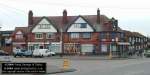
DP-310103DRAYCOTT-01
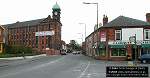
DP-310103DRAYCOTT-02
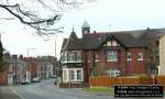
DP-310103DRAYCOTT-03
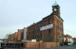
DP-310103DRAYCOTT-04
|
Home
> Draycott |
This page
features pictures and historical information about the following:
Draycott, This is located in Derbyshire.
|
If you would like
to see photos of other Areas of Derby, Derbyshire and the Midlands then
click on the main index button at the bottom of this page. |
| •
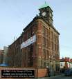
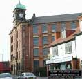
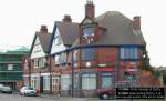
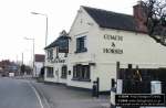
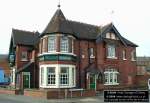
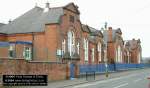
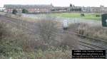
Photos of Draycott, Derbyshire, England. Draycott is a narrow, elongated village situated between Derby and Long Eaton. The best known land mark in Draycott is Victoria Mill. Having connections with the Nottingham lace trade, Building of Draycott’s Victoria Mill was started in 1888 and was established as one of the most important lace factories in the world. When it was completed in 1907, it was the largest manufacturing mill in Europe. The four-storey building with its green-capped ornamental clock tower dominates the skyline. Currently (Winter 2004) this mill is being converted into 113 one and two-bedroom luxury apartments. For more information on the Victoria Mill development please visit the website here .. www.victoriamill.com In order to get their Derbyshire lead from Derby to the river Trent at Trent Lock, the Romans built a straight road between the two. A small community settled along this road, mentioned in the Doomsday Book in 1086 as Draicott (Dry Cote). The people at the tiny village of Wilne, located just south of Draycott gradually moved to Dry Cote as this was on higher land and not subject to the flooding. Draycott was for several centuries a farming community, but as industry grew so did Draycott. Draycott people are traditionally known as ‘Neddies’. The Olympic pub on Station road was built in the mid 19th century, At one time used by the railways with stables to the rear, Coachmen would bring and take people to and from the railway station. Draycott Primary school
is located on Hopewell road , just south of the railway line. |
DP-310103DRAYCOTT-01 |
DP-310103DRAYCOTT-02 |
DP-310103DRAYCOTT-03 |
DP-310103DRAYCOTT-04 |
 DP-310103DRAYCOTT-05 |
 DP-310103DRAYCOTT-06 |
 DP-310103DRAYCOTT-07 |
 DP-310103DRAYCOTT-08 |
 DP-310103DRAYCOTT-09 |
 DP-310103DRAYCOTT-10 |
 DP-310103DRAYCOTT-11 |
 DP-310103DRAYCOTT-12 |
| Click
the button below to go to the main index of www.derbyphotos.co.uk |
| |
© www.derbyphotos.co.uk